Mohave County was one of the original four Arizona counties created by the First Territorial Legislature in 1864. During 1887 in a general election, Kingman became the county seat.
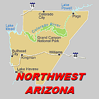
The county includes 8,486,400 acres, making it the second largest county in Arizona. The county is generally sparsely settled and includes the 'Arizona Strip'.
Most of the county is owned by the U.S. Bureau of Land Management. The county includes part or all of three Indian Reservations: Hualapai, Kaibab-Paiute, and Fort Mohave.
Other federal lands within the county boundaries include Grand Canyon National Park, Pipe Spring National Monument, Bill Williams National Wildlife Refuge, Havasu National Wildlife Refuge, Lake Mead National Recreation Area, and Kaibab National Forest. Lake Havasu State Park and Hualapai Mountain County Park are other government-owned parks in the county.
The climate of Mohave County is highly varied. Elevations range from a mere 482 feet above sea level at Lake Havasu City to 8,417 foot Hualapai Peak southeast of Kingman. The entire county is quite dry with some areas receiving less than 10 inches of annual precipitation. Temperatures in January in the higher mountains average near freezing while the average July temperatures in the southwestern portion of the county are above 90 degrees.
Gold, Silver, and lead-zinc mines brought many people to the county from the mid-1800s to the early 1900s. Important mines included White Hills (silver), Tennessee (lead-zinc), Golconda (lead-zinc), Moss (gold), Goldroad (gold), Tom Reed and United Eastern (gold), McCracken (silver), and Signal (silver). The Tom Reed and United Eastern gold mines were the richest gold mines in Arizona, operating until the 1930s.
The Atlantic and Pacific Railroad (later to become the Atchison, Topeka and Santa Fe) crossed Mohave County, reaching the Colorado River in 1883. Kingman was one of the towns founded along the main line. |